A changeable weather pattern will bring rounds of rain and temperature swings to the Northeast for the final days of April and the first few of May. The series of storms and cold fronts making for the topsy-turvy weather will not be equal opportunity, however, as parts of the region will miss out on meaningful rain and experience a continued risk for wildfires, warn AccuWeather meteorologists.
The first round of rain in association with this dynamic pattern was moving through the Northeast this weekend. While localized downpours and even gusty winds can occur into Saturday night, the rain is much-needed, not just because it has been about two weeks since the last meaningful rain in parts of the area but because pollen has been building up much to the chagrin of allergy sufferers.
AccuWeather.com
A cold front moving through behind this area of rain will usher in a drier second half of the weekend, but it will also bring an enhanced risk for fires due in part to gusty winds. This cycle will repeat itself at least once more in the coming week, and it will come in the wake of recent major wildfires in the region.
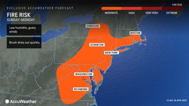
Gusty winds to lead to an elevated risk for fires into Monday
A drier, cooler air mass will allow the masses to resume outdoor activities during the second half of the weekend in the Northeast, but it will bring its own problems, warn AccuWeather meteorologists.
“Despite the rain Saturday, a fire threat will quickly return to parts of the Northeast and mid-Atlantic on Sunday,” said AccuWeather Senior Meteorologist Dan Pydynowski. “This includes much of New Jersey and Pennsylvania, where there have been large fires recently.”
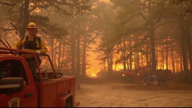
Smoke fills the sky as firefighters battle a wildfire in Lacey Township, New Jersey, on Tuesday, April 22, 2025. (New Jersey Department of Environmental Protection via AP)
The Jones Road Fire, which has scorched over 15,000 acres in Ocean County, New Jersey, and is 60 percent contained, as of early this weekend, was one of those fires. Other large blazes occurred in central Pennsylvania.
“Afternoon relative humidity values across much of the region can drop to around 30 percent Sunday,” warned Pydynowski. “This lowering of the humidity, coupled with northwesterly wind gusts of 35 to 40 mph and plenty of sun will quickly dry out brush, grass, leaves, pine needles and other fine fuels which can cause any small fire to quickly spread out of control.”
AccuWeather.com
Because of the enhanced risk, outdoor burning is not advised from eastern West Virginia and Virginia north to southern New England to end the weekend. Even something as benign as mowing the lawn or string trimming near metal edging can create sparks that can turn into infernos.
While winds will be lighter by Monday, continued dry conditions will still keep the risk for fires elevated.
More opportunities for rain, but also fires later in the week
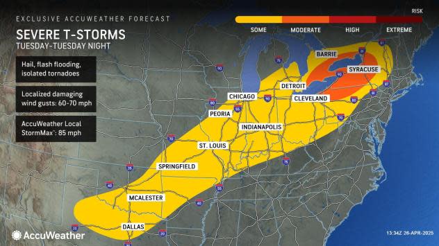
Following that round of dry weather that will last into the start of Tuesday for many, another front in association with rain and thunderstorms will arrive by Tuesday night and early Wednesday, say AccuWeather meteorologists.
AccuWeather.com
While this front can again bring locally heavy rain, and even a threat of severe weather for some, it will tend to lose energy and moisture as it approaches the Atlantic coast. Behind the front later Wednesday, another round of gusty winds and lower humidity levels can once again increase the risk for fires, especially in southern New England.
Depending on the progress of another storm and front late in the week, it’s possible there can be a third opportunity for fire danger in the region during the first weekend in May.
GET THE FREE ACCUWEATHER APP
Despite the rounds of dry, gusty winds in the wake of storms and fronts, there will be some opportunities for much-needed rain in the region. According to the latest Drought Monitor released Thursday morning, severe drought conditions were still present in portions of Maryland, New Jersey, Pennsylvania and West Virginia, despite improvements seen in March and early April.
Temperature swings and even a risk of frost for some this week?
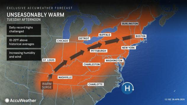
Accompanying the rounds of rain and then drier weather will be wild temperature swings, which will see the mercury rise into the 80s some days and then dive into the 60s the next in parts of the Northeast and mid-Atlantic.
AccuWeather.com
An initial cooldown to end the weekend will be replaced by a surge in temperature Tuesday afternoon, with the mercury rising well into the 80s as far north as New York City. As quickly as it warms, it will cool back down for the middle and end of the week.
In addition, a late-season frost will be possible over the course of a couple of nights in the normally cooler enclaves of the interior Northeast, Sunday night, Wednesday night and perhaps again late in the upcoming weekend.
Want next-level safety, ad-free? Unlock advanced, hyperlocal severe weather alerts when you subscribe to Premium+ on the AccuWeather app. AccuWeather Alerts™ are prompted by our expert meteorologists who monitor and analyze dangerous weather risks 24/7 to keep you and your family safer.
Read the full article here