The South and Ohio Valley will continue to be pummeled by a particularly dangerous flooding event from multiple bouts of extreme rainfall as well as severe weather that could spawn strong tornadoes this weekend.
What’s Happening Right Now
As you can see in the current radar image below, areas of heavy rain are finally pushing eastward across the South. Dozens of flash flood warnings extend across these areas.
(MORE: Latest News Updates)
Here’s a look at some notable reports since Friday:
-Rare flash flood emergency warnings were issued overnight for serious flooding in Texarkana, Texas/Arkansas, and Van Buren, Missouri. Flash flood emergencies have also been issued in Nashville, Little Rock and in northern Arkansas. Water rescues were reported in those locations.
-On Friday, a child was killed by floodwaters in Frankfort, Kentucky, and water rescues were reported in parts of Kentucky and West Virginia. Evacuations because of high water occurred in Hopkinsville and Mount Sterling, Kentucky.
-The highest rainfall total so far from this multiday heavy rain event is 13.4 inches in Mayfield, Kentucky, which is in western Kentucky. You can see other rainfall totals here.
-Flooding has been reported from northeast Texas to northern Kentucky since Saturday morning.
Current Radar, Watches And Warnings
The map below shows estimated rainfall and flood reports (blue circles) over the past 72 hours in the South and Midwest. There have been more than 650 reports of flooding in that time, mainly from the ArkLaTex to the Ohio Valley.

Estimated Rain And Flood Reports Last 72 Hours
Flood Forecast
-Timing: Through Saturday night, heavy rain will continue to soak many of the same areas that have been pummeled repeatedly the past few days, from the ArkLaTex to the Mississippi and Ohio valleys. That includes Little Rock, Arkansas; Memphis, Tennessee; Paducah and Louisville, Kentucky; Cincinnati and many other cities.
Flood watches have been issued by the National Weather Service across these regions, which means additional flooding is possible.
Dry conditions will return on Sunday and last into the first half of next week, but river flooding will linger for many days after the heavy rain exits.
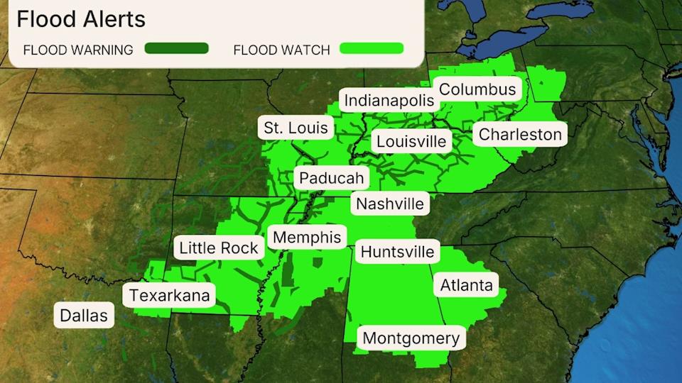
Flood Alerts
-Flooding Impacts: NOAA’s Weather Prediction Center has issued a rare high risk for flooding through Saturday night, including from much of Arkansas to southeast Missouri, northwestern Mississippi, western Tennessee and western Kentucky, as shown in pink below. NOAA found that one-third of flood-related fatalities and 80% of flood-related damage in the U.S. happens on these high risk days.
Both flash flooding and flooding of rivers, creeks and streams will occur. The NWS is forecasting rivers to reach moderate to major flood stage in over 150 locations, including a few stretches of the Mississippi and Ohio Rivers. A few tributaries may eventually rise to near record levels, but not on the mainstem Mississippi or Ohio Rivers.
According to the NWS Paducah, Kentucky, office, “Flooding may occur in homes, businesses and other locations not normally subject to flooding.” And in some areas this river flooding will last well into next week, or perhaps the following week as all this water drains through the river basins.

Flood Outlook
-How Much Rain? Potentially historic rainfall totals are possible from the Ozarks into the mid-South and mid-Mississippi and lower Ohio valleys. Storm totals over a half-foot are already widespread and some areas will likely reach double-digits, possibly up to 15 inches when all has fallen.
According to the National Weather Service in Little Rock, Arkansas, this rainfall over four days in Arkansas “is an event that happens once in a generation to once in a lifetime.”
Keep in mind the rainfall forecast below is in addition to what has already fallen the past couple of days.

Additional Rainfall Forecast
-What To Do: If you encounter a flooded road, never attempt to drive through it. It only takes about 1 foot of water to float a car or small SUV. Once your vehicle floats, you’ve lost control. Not only that, the road under the floodwaters may have been washed away.
If you live in a flood-prone area, be sure to stay alert for the latest National Weather Service flood watches and warnings and know where to quickly head to higher ground if needed. Follow the advice of local officials if you are ordered to evacuate.
“Communities in the region should prepare for possible long duration and severe disruption to daily life,” wrote NOAA’s Weather Prediction Center in a forecast discussion Thursday morning.
Severe Thunderstorm Forecast
-Overnight: Strong thunderstorms, with the threat of a few tornadoes and damaging winds, are likely to continue eastward through Mississippi, Alabama, Tennessee and eastern Louisiana.
-Sunday: The threat of severe storms will be more isolated, but could impact parts of Georgia, Alabama, southern Mississippi, southeast Louisiana and the Florida Panhandle. Wind damage is the biggest concern, but a few tornadoes are possible.

Sunday’s Severe Thunderstorm Forecast
Read the full article here