We’re in the middle of yet another day of dangerous storms as part of a multiday outbreak that has already claimed more than two dozen lives. Follow along below for all the latest details, and here’s our complete forecast and maps tracker page.
(08:41 p.m. EDT) ‘Life-Threatening Situation’ For Garfield, Kansas
Another serious tornado threat is happening now in Kansas, where a “Particularly Dangerous Situation” tornado warning has been issued for parts of Pawnee and Edwards counties. This includes the town of Garfield.
(08:22 p.m. EDT) Damage Confirmed In Grinnell, Kansas
A concerning update to a story we are tracking: Tornado damage has been confirmed in Grinnell, and rescue crews are heading toward the town. We’ll update further as we get more information.
(08:09 p.m. EDT) Vehicle Flipped Near Grinnell, Kansas
We’re still waiting for word about how the town of Grinnell fared, but there are reports of vehicles damaged along Interstate 70 just outside the town. Storm chaser Matt Coker said the people who were inside this Porsche were OK.
(08:04 p.m. EDT) Large Tornado Threatens Grinnell, Kansas
Located along Interstate 70 in northwestern Kansas, there were rising concerns for the town of Grinnell as a tornado was in progress. It wasn’t immediately clear if the twister struck the town directly or if it was simply a close call.
(07:48 p.m. EDT) Huge Hail Also Reported In Oklahoma
In addition to the tornadoes that have been in progress this evening, supercells have also been producing some very large hail, like this hailstone that was spotted not far from Arnett, Oklahoma, and was reportedly about the size of a softball:
(07:34 p.m. EDT) Stunning Look At Oklahoma Tornado
Here’s another storm chaser’s vantage point of that tornado that was in progress earlier near Arnett, Oklahoma:
(07:18 p.m. EDT) Huge Tornado Spotted In Western Kansas
Storm chaser Jake Werth just shared video of a large tornado in progress near Scott City, Kansas. That’s in the western portion of the state.
(07:00 p.m. EDT) Ground Truth Of Oklahoma Tornado
The tornado that was previously reported near Arnett, Oklahoma, has been confirmed by several storm chasers who are in the area.
(06:45 p.m. EDT) Tornadoes Spinning Up In Texas, Oklahoma, Kansas
We’re now beginning to see reports of tornadoes in progress across the Plains in some of the highest-risk areas for the evening. A tornado was reported south of Higgins, Texas, in the Panhandle, and another twister was spotted by an off-duty National Weather Service employee just north of Kanorado, Kansas. Chasers with Live Storms Media were also tracking a tornado near Arnett, Oklahoma, which may be the same twister as the one reported in Higgins.
(06:23 p.m. EDT) Homes Damaged Southeast Of Denver
In Elbert County, southeast of Denver, the Elizabeth Fire Protection District shared this update after this afternoon’s reported tornadoes: “19 homes damaged from minor to severe. 28 firefighters are on scene assessing damage.”
(06:10 p.m. EDT) Resetting The Scene
If you’re just joining us, it’s already been a busy evening and there’s a long way to go. Here are the active watches and how long they’re expected to last:
(05:57 p.m. EDT) Storms Also Firing Up In Arkansas
Have a look at this incredible image as storms intensified in parts of northwestern Arkansas this evening.
(05:42 p.m. EDT) Two Tornadoes At Once!
That’s what was documented in the area east of Denver this afternoon. Local meteorologist Cory Reppenhagen shared this video showing the two twisters in progress at the same time.
(05:28 p.m. EDT) The Latest Out Of Bennett, Colorado
In an update, the Adams County Sheriff’s Office said at least three houses were damaged or destroyed by the tornado that struck Bennett, but no injuries have been reported.
(05:08 p.m. EDT) New Video Of Colorado Tornado Tossing Debris
Storm chaser Scott McClellan shared a video to X that showed the Elkhorn Ranch, Colorado, tornado while it was in progress about an hour ago.
(04:53 p.m. EDT) New Tornado Watch Issued
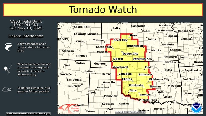
From weather.com meteorologist Tiffany Savona:
A new tornado watch has been issued for southwestern Kansas and western Oklahoma until 10 p.m. CDT. According to the Storm Prediction Center, a few tornadoes are possible and a couple could be intense (EF3 or stronger). Widespread large hail (up to 3 inches in diameter) and damaging wind gusts up to 70 mph are all possible.
(04:38 p.m. EDT) Where The Worst Storms Could Be Tonight
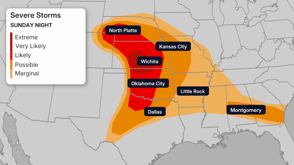
Here’s a look at the latest severe weather outlook for tonight. While it’s important to remember that anywhere in the shaded areas could see dangerous storms, the highest risk for strong tornadoes and damaging winds is in the red areas.
(04:26 p.m. EDT) Scenes Of Damage East Of Denver
We’re getting our first visuals of the damage left behind by a reported tornado near the towns of Bennett and Watkins, located along Interstate 70 east of Denver. It wasn’t immediately clear how many buildings were damaged or if there were any injuries.
(04:14 p.m. EDT) Passengers Watch Tornado In Progress From Denver Airport
At Denver International Airport, passengers watched from their terminals as a tornado spun out in the distance. The airport was under a ground stop due to the storms.
(04:00 p.m. EDT) ‘Significant’ Damage Reported Southeast Of Denver
Tornadoes are in progress in parts of eastern Colorado. One damaging storm was moving in the direction of Strasburg and Bennett along Interstate 70 east of Denver, but not before reportedly causing damage in the Elkhorn Ranch area.
Traffic cameras showed what appeared to be a tornado crossing I-70.
Read the full article here